Prorating data when units do not nest neatly
Warning
We strongly urge you not to prorate by area! The area of a census block is not a good predictor of its population. In fact, the correlation goes in the other direction: larger census blocks are less populous than smaller ones.
Suppose you have a shapefile of precincts with some election results data and you want to join that data onto a different, more recent precincts shapefile. The two sets of precincts will have overlaps, and will not nest neatly like the blocks and precincts did in the above examples. (Not that blocks and precincts always nest neatly—in fact, they usually don’t!)
In most cases, election data should be prorated from each old precinct to the new precincts with weights proportional to the population of the intersections between the old precinct and each new precinct. The most straightforward way to accomplish this is to first disaggregate the data from the old precincts to Census blocks as in the example above, and then reaggregate from blocks to the new precincts.
>>> old_precincts = precincts
>>> new_precincts = geopandas.read_file("zip://./examples/new_precincts.zip").to_crs(32030)
>>>
>>> election_columns = ["SEN18D", "SEN18R"]
>>>
>>> blocks_to_old_precincts_assignment = maup.assign(blocks, old_precincts)
>>> blocks_to_new_precincts_assignment = maup.assign(blocks, new_precincts)
>>>
>>> # We prorate the vote totals according to each block's share of the overall
>>> # old precinct population:
>>> weights = blocks.TOTPOP / blocks_to_old_precincts_assignment.map(blocks.TOTPOP.groupby(blocks_to_old_precincts_assignment).sum()).fillna(0)
>>> prorated = maup.prorate(blocks_to_old_precincts_assignment, precincts[election_columns], weights)
>>>
>>> # Add the prorated vote totals as columns on the `blocks` GeoDataFrame:
>>> blocks[election_columns] = prorated
>>>
>>> new_precincts[election_columns] = blocks[election_columns].groupby(blocks_to_new_precincts_assignment).sum()
>>> new_precincts[election_columns].round(2).head()
    SEN18D   SEN18R
0   728.17    49.38
1   370.00    21.00
2    97.00    17.00
3    91.16     5.55
4   246.00    20.00
As a sanity check, let’s make sure that no votes were lost in either step. Total votes in the old precincts, blocks, and new precincts:
>>> old_precincts[election_columns].sum()
SEN18D    23401
SEN18R     3302
dtype: float64
>>>
>>> blocks[election_columns].sum()
SEN18D    23401.0
SEN18R     3302.0
dtype: float64
>>>
>>> new_precincts[election_columns].sum()
SEN18D    20565.656675
SEN18R     2947.046857
dtype: float64
Oh no - what happened??? All votes were successfully disaggregated to blocks, but a significant percentage were lost when reaggregating to new precincts.
It turns out that when blocks were assigned to both old and new precincts, many blocks were not assigned to any precincts. We can count how many blocks were unassigned in each case:
print(len(blocks))
print(blocks_to_old_precincts_assignment.isna().sum())
print(blocks_to_new_precincts_assignment.isna().sum())
3014
884
1227
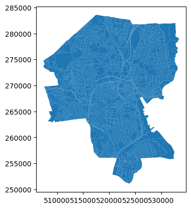
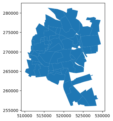
So, out of 3,014 total Census blocks, 884 were not assigned to any old precinct and 1,227 were not assigned to any new precinct. If we plot the GeoDataFrames, we can see why:
>>> blocks.plot()
>>> old_precincts.plot()
>>> new_precincts.plot()
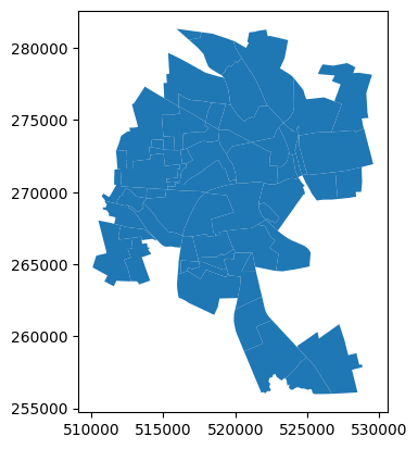
The boundaries of the regions covered by these shapefiles are substantially different—and that doesn’t even get into the possibility that the precinct shapefiles may have gaps between precinct polygons that some blocks may fall into.
Once we know to look for this issue, we can see that it affected the previous example as well:
>>> blocks[variables].sum()
TOTPOP      178040
NH_BLACK     23398
NH_WHITE     66909
dtype: int64
>>>
>>> precincts[variables].sum()
TOTPOP      140332
NH_BLACK     19345
NH_WHITE     46667
dtype: int64
Moral: Precinct shapefiles often have terrible topological issues!
These issues should be diagnosed and repaired to the greatest extent possible before moving data around between shapefiles; see Fixing topological issues, overlaps, and gaps below for details about how maup can help with this.